Soil Information System
The Soil Information System™ solution, part of the Trimble® Connected Farm™ solution, is an industry-leading soil mapping technology that uses advanced sensors,
intelligent targeting and geo-processing algorithms to produce high-resolution, accurate soil and topographic information. By providing a greater understanding of
the physical and chemical characterization of the soil, including how inputs move through the soil, the Soil Information System enables farmers' trusted advisors
to implement more effective solutions to resolve the unique challenges of each area of their fields. This information can be used to make critical farm management
decisions with irrigation, drainage, fertility, and more.
Some of the features of the Soil Information System are:
Some of the features of the Soil Information System are:
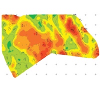
- Ability to assess detailed soil properties for each field such as soil texture, compaction, root zone depth, moisture retention and availability, and soil fertility
- View soil analysis of the top four feet of the field's surface in 3D
- Output soil chemical and physical characteristic maps that are highly accurate with two meter management level
- Download soil maps into your farm management software application, including Farm Works Software® solutions or other third-party systems
SIS Surfer
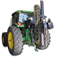
The SIS Surfer is an electro-conductivity (EC) or electro-magnetic (EM) geophysical sensing system that is used to conduct a conductivity survey of the soil. The Surfer system
consists of the EC or EM device housed inside a sled that is connected to an ATV or similar vehicle, a guidance display to provide parallel swathing instructions to the operator,
and a Yuma® 2 ruggedized tablet that is loaded with the Soil Information System Data Analysis and Acquisition Software (DAAS).
SIS Diver
The SIS Diver is a geophysical �pushing� system used for both soil probing and physical soil core sampling. The SIS Diver is available for a variety of vehicle mounting types, based
on in-field requirements. The SIS Diver system consists of the hydraulic pushing system, Soil Information System specifically designed soil probe, soil coring system, and a Yuma 2
ruggedized tablet loaded with the Soil Information System Data Analysis and Acquisition Software (DAAS).
Data Analysis and Acquisition Software (DAAS)
DAAS is a Soil Information System exclusive software platform that allows the user to collect each step of the Soil Information System data collection solution, without having to leave
the field. The software�s built-in, advanced geo-processing algorithms allow the user to create intelligently placed soil target locations. The DAAS software enables you to visualize
field data collection in real-time, combines several layers of data quality checks, and ensures a complete dataset is captured the first time; eliminating costly trips back to the mapping site.